
THE INDIANA COMPETITION
The 2023 theme for our statewide selection for the national competition is
Discovering Indiana & the World Through GIS
The maps should be about places and themes related to Indiana and tell a compelling story. What kind of story could be told with maps? There is a wide range of possibilities, from the local ecology of your hometown, stories about immigration to your community, natural treasures in your community/state, or peculiarities of Hoosier culture, environmental problems and other interesting topics.
THE NATIONAL COMPETITION
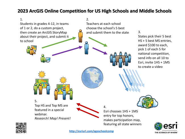
Middle and high school students and their teachers across the U.S. are invited to explore their world and create interesting online maps about their home state. The ArcGIS Online U.S. School Competition 2023 is open to middle school (grades 4-8) and high school (grades 9-12) students in the U.S. who analyze and present data via an ArcGIS Online presentation, web app, or story map.
THE PARTICIPANTS
The Geography Educators’ Network of Indiana (GENI) invites all middle and high school teachers and students to take part in this competition. All grades 4-12 public, private, or homeschooled students in Indiana (including 4th-grade elementary students) are eligible to enter the contest either through formal OR informal organizations. Each participating school can select up to 5 submissions.
THE MAP AND STORY
The competition is an initiative to stimulate the use of GIS technologies in schools and teach students to engage with their reality, analyze problems, and think critically about space and place. Participants use ArcGIS Online to tell an interesting (IN) story using data, maps, written words, photographs, videos, audio and more…a digital research paper that has a spatial component. You can find a large number of story map examples at https://www.esri.com/en-us/arcgis/products/arcgis-storymaps/stories (by professionals) and guides to get started at https://www.esri.com/en-us/arcgis/products/arcgis-storymaps/resources. ArcGIS Online is available to schools in the United States free of charge. Go to http://www.esri.com/industries/education/software-bundle#%20 to sign up for a free ArcGIS Online school organization (secure) account.
PRIZES
All students who submit maps and their teachers will receive a participation certificate from the Geography Educators’ Network of Indiana (GENI). The five maps judged the best in each category (middle school and high school) will be
awarded $100 Amazon.com gift certificates.
HOW TO GET STARTED?
Samples from previous competitions and additional information are available at the 2023 AGO link below or http://esriurl.com/agoschoolcompinfo (full details).
For further materials and assistance, please, get in touch with Jörn Seemann (mappingindiana@gmail.com), go the Mapping Indiana Facebook Group (https://www.facebook.com/groups/2467716709977131/) or visit the GENI website for updates (https://geni.iupui.edu).
The deadline for submitting student maps for the statewide competition is May 5, 2023 @ 5:00 p.m. Eastern Time. State Awardees will be announced on May 12, 2023.